Singapore Electronic Navigational Chart
The electronic navigational chart (ENC) is a digital chart product intended to be used in conjunction with Electronic Chart Display and Information System (ECDIS).
The Electronic Navigational Chart (ENC)
The electronic navigational chart (ENC) contains information on features useful for navigation such as bathymetry (water depths), coastlines, obstructions, beacons etc. and complements traditional paper charts. Fully compliant with the chart standards and specifications set by the International Hydrographic Organization (IHO),in particular S57 Edition 3.1, the ENC contains supplementary nautical information useful for safe navigation above and beyond what is shown on traditional paper charts.
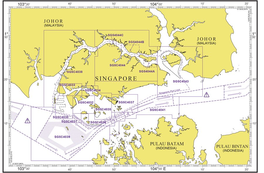
The latest edition of the Singapore ENC covers Singapore Port Waters and their approaches.
The Electronic Chart Display and Information System (ECDIS)
The Electronic Chart Display and Information System (ECDIS) is a navigation information system which is considered the legal equivalent of the nautical chart, displaying selected information from an ENC. It is integrated with data from positional and, optionally, other sensors.Both the ECDIS software and hardware comply with the ECDIS performance standards set by the International Maritime Organization (IMO).
The Maritime and Port Authority of Singapore (MPA) has invested in additional supporting infrastructure such as the Differential Global Positioning System (DGPS) broadcast service, which can be used with ECDIS to improve positioning accuracy and navigational safety.
A powerful navigational tool, the ECDIS when interfaced with navigational sensors such as DGPS is able to provide:
Real-time positioning: The system is able to track the actual position of the vessel and display it in real-time.
24-hour, all-weather: It is able to operate in all weather conditions, both day and night, thus enhancing navigational accuracy critical in confined waters.
Anti-grounding and anti-collision warnings: The ECDIS can provide anti-collision and anti-grounding warnings, when interfaced respectively with an Automatic Radar Plotting Aid (ARPA) and an echo sounder.
Easier navigation: The ECDIS has the capacity to carry out course planning, route monitoring, waypoint checking and estimated time of arrival (ETA) calculation.
Benefits
The Singapore ENC when used with the ECDIS further enhances safe navigation within Singapore waters and its approaches. As the system is approved by IMO as a paper chart equivalent, vessels equipped with it need not carry paper charts as is normally required under the Safety of Life at Sea (SOLAS) Convention.
Coverage
The Singapore ENC consists of 16 harbour category cells covering Singapore waters and its approaches:
| Cell name | Coverage |
|---|---|
| SG5C4030 | West Jurong Anchorages and Temasek Fairway |
| SG5C4031 | Western Approaches to Jurong Island |
| SG5C4032 | Sinki Fairway |
| SG5C4033 | Tuas Bay, West Jurong Channel and Pesek Basin |
| SG5C4034 | East Jurong Channel, Pasir Panjang Terminal and West Keppel Fairway |
| SG5C4035 | Western Anchorages, Jong Fairway and Cruise Bay |
| SG5C4036 | Raffles Lighthouse to The Sisters |
| SG5C4037 | Keppel Harbour, Tanjong Pagar Terminal and Approaches |
| SG5C4038 | Johor Strait – Western Part |
| SG5C4039 | Western Approaches to Main Strait |
| SG5C4041 | Pulau Sebarok to Changi |
| SG5C4043 | Kuala Johor and Sungai Johor |
| SG5C4044 | Johor Strait – Eastern Part |
| SG54044A | Serangoon Harbour |
| SG54044B | Pelabuhan Johor (Johor Port) |
| SG54044C | Sembawang |

How to access or purchase
To access, view and navigate with the Singapore ENC, it must be used in conjunction with a type-approved ECDIS, which is available from authorised commercial vendors.
Registered Singapore ENC users can obtain monthly incremental updates from their Singapore ENC distributor.
Singapore ENC distributors
CONTACT PERSON/ DESIGNATION | ADDRESS | CONTACT |
|---|---|---|
PRIMAR STAVANGER
| Lervigsveien 36, P.O Box 60, | Tel. No.: +47 51 93 9500 |
The United Kingdom Hydrographic Office
| Admiralty Way,Taunton, | Tel. No.: +44 1823 33 7900 |
Enquiries
Please direct any further enquiries that you may have to:
The Hydrographic Division
Maritime and Port Authority of Singapore
7B Keppel Road
#20-00 Tanjong Pagar Complex
Singapore 089055
Tel: 1800 272 7777 / +65 6272 7777 (if calling from overseas)
Email: hydrographic@mpa.gov.sg
FAQ
A1: The Singapore Electronic Navigational Chart (ENC) is a digital database containing hydrographic chart information covering Singapore waters and its approaches. It is necessary for safe navigation and supplements data that is in paper charts. Produced and quality assured by the Hydrographic Department of the Maritime and Port Authority of Singapore (MPA), the Singapore ENC complies with the International Hydrographic Organization (IHO) S57 Edition 3.1 specifications.
A2: The Singapore ENC was developed to supplement the traditional paper format. In 1994, the Hydrographic Department of the Maritime and Port Authority of Singapore (MPA) embarked on a project to produce the ENC. The first official Singapore ENC was released for commercial use in 17 March 1998.
Malacca and Singapore Straits Electronic Navigational Chart
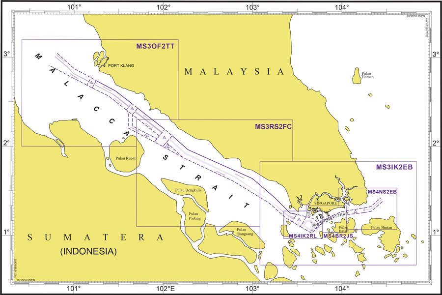
The Malacca and Singapore Straits Electronic Navigational Chart (MSS-ENC) covers from One Fathom Bank in the Malacca Strait to Eastern Bank in the South China Sea.
Benefits
The MSS-ENC is an official ENC, meeting the International Hydrographic Organization specifications and standards. Used together with ECDIS, it enhances safe navigation and meets Safety of Life at Sea (SOLAS) Convention chart carriage requirements.
The latest 7th Edition of the MSS-ENC includes updated information from the joint hydrographic surveys of areas critical to navigation in the Straits. The MSS-ENC now includes additional information in the form of one-metre contour depth intervals in under keel clearance-critical areas which would enable more accurate determination of under-keel clearance and enhanced navigational safety and efficiency for vessels transiting the Straits.
Cell Name | Coverage |
|---|---|
MS3OF2TT | One Fathom Bank to TanjungTuan |
MS3RS2FC | Raleigh Shoal to Fair Channel |
MS3IK2EB | IyuKechil to Eastern Bank |
MS4IK2RL | IyuKechil to Raffles Lighthouse |
MS4BR2JS | Buffalo Rock to Johor Shoal |
MS4NS2EB | Nongsa to Eastern Bank |

For further information, please contact:
Japan Hydrographic Association (JHA)
Email: enc-support@jha.jp
Website: http://www.jha.or.jp/en/jha/purchase/distributors_world.html
- International Hydrographic Organization (IHO)
- International Maritime Organization (IMO)
- Differential Global Positioning System (DGPS)
- United Kingdom Hydrographic Office
- Hydrographic Division
